Adding Value to Right-of-Way Management
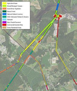
Example of typical GIS ROW analysis mapping for electric utilities.
A system-wide approach to Right-of-Way (ROW) assessment can help utility and energy companies meet regulatory compliance needs and advance corporate stewardship goals by identifying innovative strategies to manage vast networks of transmission, distribution, and storage infrastructure corridors more efficiently and cost-effectively.
Wetland Studies and Solutions brings a big-picture GIS-based process to ROW management that differs from the conventional area-by-area piecemeal approach. Our ROW Baseline Condition Assessments give clients the system-wide data they need to address the following priorities across their entire ROW network:
- Regulatory compliance and safety
- Efficient and organized maintenance scheduling and operation
- Improved budget forecasting and planning
- Positive and informed interaction with stakeholders/landowners
- Habitat enhancement
With visibility throughout their entire network, clients can approach ROW management in a purposeful and systematic way – while more effectively prioritizing both schedule and cost for vegetation management efforts, habitat best management practices, and public outreach opportunities.
By harnessing the data in these GIS-based assessments, we are able to help clients identify and pursue additional cost-saving strategies and best practices in vegetation and habitat management so they can reach their long-term goals.
Example of typical GIS ROW analysis mapping for natural gas utilities.
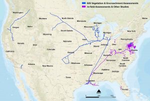
WSSI has provided GIS-based assessments across 30 US States, 14,700 miles, and 260,600 acres.
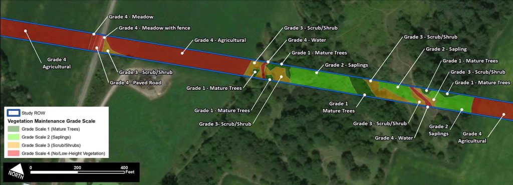
The data foundation of a ROW Baseline Condition Assessment is typically a GIS database with vegetation mapping and encroachment inventories for the energy infrastructure system as defined by the client. Depending on client needs, our scientists can field-verify the GIS analysis across select sample sites, providing photo documentation and real-time updates to characterize field conditions. The assessments can be tailored to include more detail to inform management decisions, including:
- Vegetation height (mature, sapling, shrub, meadow)
- Land use (residential, commercial, industrial, agriculture)
- Encroachments/observations (fences, gates, houses, structures, sheds, pools, cemeteries, junk, equipment, brush piles, pavement, exposed rock, disturbed earth, landscaping/specimen trees, steep slope areas, driveways, dirt roads, wetlands/waterbodies, crop type, livestock present, and utility easement crossings),
- Comprehensive habitat inventory components for analysis
To learn more about our ROW Baseline Conditions Assessments and how you can convert ROW corridors from a liability to an asset, please contact those listed below.