VMRC Draft Wetland Guidelines Out for Public Comment
Update, March 24, 2021, post-publication: The Public Comment period has been extended, and will now close on April 16 rather than March 31 as originally stated. Visit VMRC’s webpage for more information.
Virginia has updated the stabilization regulations for eroding shorelines; comments on the draft regulations are due April 16.
On March 1, 2021, the Virginia Marine Resources Commission (VMRC) released revised draft Wetland Guidelines. The draft Guidelines were developed pursuant to the 2020 Virginia General Assembly’s Senate Bill 776, which strengthened VMRC’s mandate to protect sensitive shorelines and wetlands by amending the language regulating Virginia’s tidal wetlands (Chapter 13, Title 28.2 of the Code of Virginia); this was the first revision to these guidelines since 1993. Wetland Studies and Solutions, Inc. (WSSI) has reviewed the draft Guidelines, which are out for public comment through April 16 (details for commenting are provided below).
The two big changes in the amended regulations are simplification of the tidal wetlands definition and the requirement to implement living shoreline measures for shoreline stabilization projects when possible.
Tidal Wetland Definition
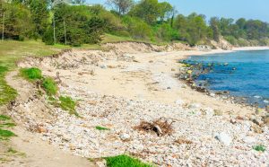
What is a Living Shoreline?
A living shoreline is a means of shoreline protection that incorporates stone, plants, sand, and other structural organic materials (e.g., woody material). This approach is now, by regulation, the preferred approach over “hard” structure, where practicable (e.g., rip rap, construction debris, bulkheads). Research has shown that living shorelines conserve, create or restore natural shoreline habitats and ecosystem services while providing protection from wave energy and sea level rise. You can learn more about living shorelines on the website for the Virginia Institute of Marine Science.
The draft regulations recognize two types of tidal wetlands: vegetated and non-vegetated. This is a significant simplification, as the guidelines previously recognized 17 types – 12 vegetated wetland types (marshes) and 5 non-vegetated wetlands (tidal flats and beaches).
With the new classification system, the tidal wetland types are delineated by elevation, relative to mean high and mean low tide.
- Non-vegetated wetlands are located between the mean high tide line and the mean low tide line, i.e., mud flats and beaches.
- Vegetated wetlands are located upslope of mean sea level to an elevation equivalent to 1.5 times the mean tide range above mean low tide.
The regulatory significance of these elevations has not changed with these amended guidelines.
Preference for Living Shoreline Stabilization
The default assumption – which is now incorporated in the draft Guidelines – is that a living shoreline approach to shoreline management techniques will be required unless the best available science shows that such approaches are not suitable. Even then, VMRC will require incorporation, to the maximum extent possible, elements of living shoreline approaches into permitted projects.
Projects should use living shoreline treatments when suitable (as outlined in these draft Guidelines), and failure to do so will result in denial of the application by the Commission or the local wetland board.
Other Minimum Permitting Standards
Applications will be considered incomplete – and not eligible for public hearings – when the project does not adequately address particular permitting conditions.
- Water Quality Impact Assessments (WQIAs) are part of the complete submission package.
- When a non-living shoreline erosion control project involves removing vegetation in the Resource Protection Area (RPA) and the local government requires a WQIA and an erosion and sediment control plan, those two components must be completed before VMRC will schedule a public hearing.
- If a living shoreline is used, the locality approves the project, riparian vegetation is maintained or established, and impacts are minimized, the Board may schedule the public hearing without a WQIA.
- Mature tree preservation and inclusion in project design is critical, and encouraged to the “maximum extent practicable.” The draft Guidelines caveat that projects should do so in a manner “consistent with the best available technical advice and permit conditions or requirements.”
- Applications must provide site-specific data on scaled drawings, including the following; additional conditions may also apply.
- area of impact
- existing and proposed wetland types
- existing and proposed grade elevations and slope
- mean high, mean low and 10-year storm event water levels as calculated by the National Oceanographic and Atmospheric Administration (NOAA) and the Federal Emergency Management Agency (FEMA)
- existing bathymetric elevations to the minus 1-foot mean low water elevation
- the current shoreline condition of adjacent properties, including any existing treatments
- Applications must demonstrate “review and consideration of data derived from existing online advisory tools, engineering analyses or other online tools that facilitate the measurements of fetch, depth offshore, shoreline morphology, shoreline orientation, nearshore morphology, submerged aquatic vegetation (SAV), tide range, storm surge frequency, erosion rate, design wave determination, and sea level rise.”
WSSI Can Help
If you have questions regarding the draft Guidelines and how these changes may affect your projects, please contact Mark McElroy or Bob Kerr in our Hampton Roads office, or Christie Blevins in our Gainesville office.
Comments
Comments on the draft Guidelines are due on April 16, 2021, and may be submitted by emails to wetlandsguidelines[at]mrc.virginia.gov with the subject heading “Wetlands Guidelines Comments.”
VMRC plans to review the public comments and prepare a final draft for the Commission’s consideration, potentially at the meeting scheduled for May 25, 2021. More information is available on the VMRC website.