The City of Roanoke and WSSI collaborated to develop a Resilience Plan framework document for future efforts related to repetitive flooding, flood preparedness and resilience.
The Challenge
Develop a Resilience Plan framework for the City of Roanoke to address flood preparedness and resilience and support future planning and grant applications.
Our Solution
WSSI worked with local stakeholders, our custom GIS-based data collection tool, and existing City plans and infrastructure information to conduct a gap analysis that leads to the next steps in Roanoke’s flood preparedness efforts. The project selection matrix we helped develop is a tool that can be used by the City but also applied to other local governments interested in improving their resilience planning. This work was conducted under a grant from the Virginia Community Flood Preparedness Fund.
The Resilience Plan focuses on the City’s floodplains, current and planned gray and green infrastructure, and stormwater management aspects of resilience. The Plan was guided by and incorporates five criteria from the Virginia Department of Conservation and Recreation: climate change, social equity, community scale benefits, economy and land use, and nature-based approach.
We conducted an extensive literature review and documented Roanoke’s past flood resilience efforts or those underway by the City and regional partners. WSSI staff reviewed City plans, protocols, policies, and programs in addition to any efforts relating to resiliency, stormwater management, floodplain management, severe weather events, and comprehensive planning. The team then evaluated the City’s environmental assets, engineered defenses, and adapted structures already in place for protection against flooding to understand the role of existing green and gray infrastructure. WSSI used NOAA’s MARISA IDF Curve Data Tool to evaluate the impacts of using the predicted increases in precipitation due to climate change on stormwater management and design. The Social Vulnerability Index, EJScreen, and National Risk Index FEMA models provided a measure of the overall social vulnerability of each census tract, and overlaps between these areas and repetitive flooding were incorporated into the scoring matrix and final prioritization of projects.
WSSI was the lead consultant for a robust virtual and in-person community education and engagement effort to understand more fully who flooding impacts, where those impacts occur, and how those impacts are experienced. We worked with City stormwater staff to conduct five in-person public meetings and one virtual meeting.
Our team developed a custom GIS-based online survey and mapping application to help the City capture flood occurrence data and visualize issues in a geographic context. The easy-to-use, readily accessible survey tool gave a voice to City residents who provided their firsthand flood experiences and photos to document areas of concern and inform resilience improvement efforts. The public interface showed citizens where issues were being reported, while allowing City staff to catalogue and archive reports of flooding with detailed source information. The tool was provided on the project website and also brought to the public through radio and television, including the local evening news.
During the final phase of research and plan development, the team synthesized all the findings from the literature review, models, analyses, and community engagement to inform the gap analysis and apply a ranking matrix for use in prioritizing project evaluation and implementation. Based on existing ordinances and policies, the gap analysis identified studies and projects the City could expand upon or create to boost resilience. The matrix was used to score the final list of studies and projects, using weights to prioritize those that meet the Fund’s criteria. The matrix can be further applied to future flood resilience projects.
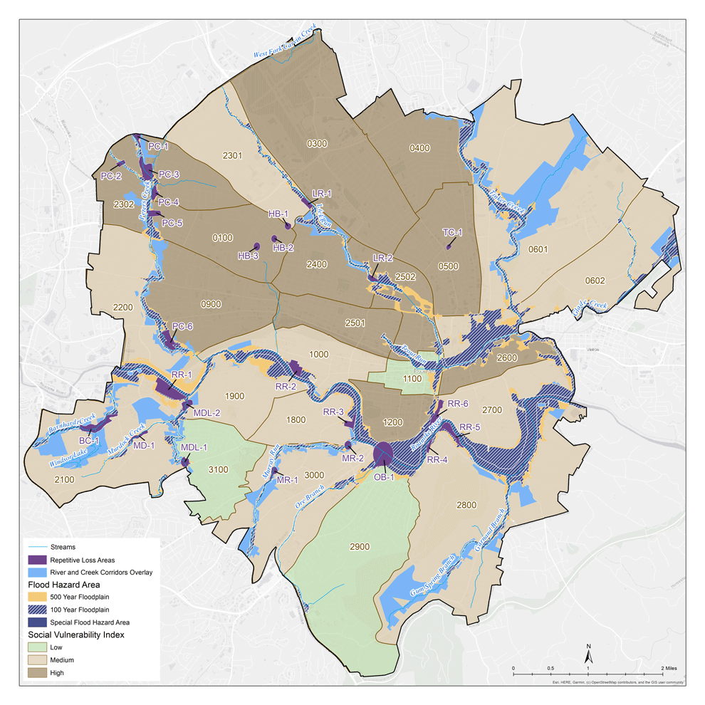
WSSI created maps to illustrate resilience matters across the City of Roanoke for the overall Plan.
Project Facts
- Owner
City of Roanoke - Location
Roanoke, VA